end-to-end spatial intelligence stack

Spatial Intelligence
for AI Systems

How AI understands and interacts with the real world

AI has no native understanding
of physical space

Most AI systems can process language. They cannot reliably understand physical space. They do not know where things are, what is happening in a place, or how context changes outcomes.

🌫️

Hallucinated Geography

LLMs fabricate details about real places (opening hours, layouts, conditions) because they have no grounded, live source of spatial truth.

📍

Pins, Not Places

Existing mapping systems give you coordinates and labels. They don't know what a place means, who it's for, or how it changes minute to minute.

🤖

Blind Autonomy

Robots and AR systems lack access to local norms, live state, and affordances. They can see geometry but can't understand context.

AI doesn't need to model the world.
It queries a system that already knows.

Today

LLM as recommendation engine

The model owns the answer. It guesses from training data, with no lineage, no confidence score, no awareness of who's asking or when.

With World Agent

LLM as orchestrator

The model queries a spatial system that already knows how to answer, powered by predictive world models that learn how places evolve over time. Context, confidence, and attribution are built in.

World Agent gives AI a structured, trustworthy understanding of real places

Every answer is grounded in real data, conditioned on who's asking, and honest about uncertainty. Not a database. Not a knowledge graph. A living spatial intelligence layer.

NOT A map database
IS A spatial intelligence layer
NOT A geocoder
IS Identity + memory + live state + meaning per place
NOT A static knowledge graph
IS A 4D graph: past, present, near-future, contested
NOT A review platform
IS Contextual, audience-aware spatial understanding

Operating system for
the physical world

Six layers. One stack. From spatial identity to operational control.

Enterprise
Control Layer
Private agents, policy enforcement, operational control
Simulation
Predictive Layer
JEPA-informed world models that predict what happens next before it does
World Agent
Reasoning Layer
Spatial agents that reason over learned world models, remember, and answer
Perception
Sensing Layer
Representations that see, measure, and detect change across modalities
Signal Network
Data Layer
Public, premium, private, and domain signals anchored to place
4D-ID
Identity Layer
Every point, object, and event gets a persistent spatial identity

Each layer depends on the one below it. Each produces value for the one above.

World Agent is built as a unified, interoperable stack: universal spatial addressing, living knowledge graphs, real-time signal integration, trust and attribution layers, execution engines optimized for different latency profiles, and developer tools for building spatial intelligence into any system.

This is not six products. It is one stack. You can enter at any layer and the ones below it work for you.

Identity Signals Perception Reasoning Prediction Control

And the substrate
it composes with.

4D-ID is how spatial systems agree on where.

4D-ID is the addressing standard underneath the spatial layer. A universal spatial addressing system that gives every place, object, and moment a unique, interoperable identity across all scales and contexts. World Agent uses it where precision matters. 4D-ID is independently useful as a standalone substrate.

Together they let AI reason about real coordinates with verifiable provenance.

Read about 4D-ID → Read the Spec →

spatial anchor

4D-ID

Identity, coordinates, alignment, temporal awareness

Composable, not fused. Each layer is independently useful.

Spatial Concepts in.
Natural Answers out.

Every spatial agent answers a small fixed set of canonical questions, divided into operational and experiential. Both kinds carry lineage; neither claims truth. The full set, with canonical wording and endpoint shapes, is specified in the technical specification.

Operational

Current state of a place. Its history and changes over time. Spatial proximity to other places. Legal and control structure. Affordances available to a visitor. The graph of relations to other agents. Predicted state over near-term horizons. Discovery across the system. Explicit absence of evidence. Appropriate channels for contact.

Experiential

Fit between a place and an asker, conditioned on cohort. The meaning of being at a place and what visiting signals. Causal effects the place tends to produce in people like the one asking. Contestation between cohorts who experience the place differently.

Live Demo | Café Query

world-agent query | site-level place agent
🔍

"Where should I work nearby?"

Q1 | Current State

Current state, occupancy, ambient conditions, affordances — returned with structured lineage

Q8 | Prediction

Predicted near-term state with stated confidence and calibration history — never a single point estimate presented as truth

Q12 | Cohort Match

Cohort-conditioned fit for the asker's cohort, with per-cohort confidence — the system never collapses cohorts into a single rating

Q15 | Contested Belief

⚠️ Where cohorts disagree, the disagreement itself is the answer — both sides preserved, never resolved by the platform. Lineage attached.

Illustrative shapes. A live interactive demo is available to design partners under NDA.

World Agent Signal Network

The data supply network that powers spatial agents with authoritative, real-time information.

World Agent leverages an established network of open, premium, and authoritative data suppliers.

The platform ingests public, premium, private, and domain-specific signals, then resolves them into trusted claims about places. Each signal is anchored to a spatial agent, resolved into grounded understanding of places through built-in trust and attribution.

Signals do not become truth automatically. They become evidence.

This lets World Agent start with broad public coverage, enrich high-value places with premium data, and create private client agents from secure, client-controlled systems.

Public

Public Signals

Open, freely available signals across mapping, civic records, transit, weather, and public imagery. Establishes baseline coverage of place.

Premium

Premium Signals

Licensed or partner signals that improve confidence, prediction, and coverage on high-value places. Includes mobility, imagery, and indoor-positioning sources.

Private Client

Private Client Signals

Client-controlled signals that never leave the tenant. Enables operational deployments where data confidentiality is a requirement.

Domain

Domain Signals

Vertical-specific signal packs co-developed with operators in tourism, real estate, logistics, civic operations, and other domains.

Derived

Derived Signals

Signals produced by perception and computation over representations of place, with full method and origin metadata.

Signal Pipeline

Signals

Spatial data from multiple sources

Resolution

Trust and attribution applied

Spatial Agents

Place-specific intelligence

Rollups

Hierarchical aggregation

Answers

Grounded spatial intelligence

Signal activation

Signals operate under multiple activation patterns appropriate to their refresh requirements and the value they provide. The full trigger taxonomy is specified in the technical specification.

World Agent is not just a spatial intelligence layer. It is also a signal network for the physical world.

Signals as a Service

World Agent can expose signal acquisition, normalization, and verification as a managed service. Clients can bring their own private signals, subscribe to premium signals, or request custom signal coverage for a place, venue, city, or domain.

Signal connectors
Managed ingestion
Spatial anchoring
Built-in trust and attribution
Policy-aware access control
Enterprise-grade isolation
Domain signal packs
On-demand signal activation

Built for speed, honesty,
and planetary scale

A hierarchical agent system where children report upward, parents summarize, detect anomalies, and predict, all with lineage and confidence at every layer.

Global Scope
Regional
Local
...
↑ Summaries flow up Context flows down ↓

Agent Hierarchy

A multi-level hierarchy from global scope down to local scope, with bounded depth. Each level owns its scope and answers within its jurisdiction. Roll-up traverses upward; drill-down traverses downward. The level scheme and addressing convention are specified in the technical specification.

Operational
What is objectively the case
Cohort
Gate
Experiential
What it means to whom
Both carry lineage. Neither claims absolute truth.

Two-Layer Truth Model

Every place maintains two kinds of truth. Operational truth is what's objectively the case: state, facts, conditions, structure. Experiential truth is what it means to whom, audience-aware and contextual. Both carry lineage.

Fastest
Control loops
🔍
Deepest
Full lineage
Latency ↔ Lineage Frontier

Execution Modes

Multiple execution modes along a single Pareto frontier between latency and lineage. Robotics-grade latency for control loops. Default latency for AI assistants and copilots. Decision-grade depth for legal review and counterfactual analysis. Always degrade explicitly: never silently, never block.

Parent Agent
Child
Child
Child
...
Intelligence flows upward. Context flows downward.

Roll-Up Flow

Children report upward. Parents summarize, detect patterns, flag risks, and predict. Intelligence flows upward through the hierarchy, giving every level a live picture of what's below it.

The infrastructure layer for
spatial applications

World Agent is the foundation that makes a new generation of spatially-aware applications possible.

🧠

Spatial Copilots

AI assistants with real-time spatial grounding. "Where should I eat?" becomes a structured answer, not a hallucinated guess.

🤖

Robotics Navigation

Autonomous agents that know norms, affordances, and live state. Your delivery robot knows the side entrance is open and the elevator is down.

🎙️

AI Tour Guides

Personalized narration anchored to real places, aware of what you've seen, what's relevant to your interests, and what just changed.

📦

Real-Time Operations

Logistics, retail, and hospitality running on live spatial state instead of stale dashboards and manual check-ins.

🏙️

Smart Cities

Civic dashboards with public lineage. Citizens and planners querying the same trustworthy spatial layer.

Adaptive Environments

Spaces that respond to intent under consent: lighting, routing, signage adjusting to who's there and what they need.

👓

AR Overlays

Digital content bound to physical places with meaning, not just coordinates. Persistent, context-aware, audience-adaptive layers.

● Case Study

HearHere: built on the World Agent framework

HearHere delivers current, personalized answers from a hierarchical World Agent spatial intelligence service. AI-powered audio tours that know where you are, what's around you, and what matters to you...right now, not last month.

It uses spatial agents across 6 hierarchy levels, 12 geofence-triggered audio cues, and a working spatially-grounded chat AI. It is the empirical proof that the spatial narrative thread of the architecture works in production, not as a prototype, as a product.

See HearHere live →
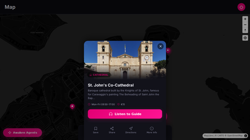
HearHere audio guide showing St. John's Co-Cathedral in Valletta, Malta with Listen to Guide button
What the World Agent protocol enables in HearHere
Spatial Identity

Every place is an agent

56 spatial agents in a real hierarchy, from the planet down to individual cathedrals and cafés. Each place is a spatial agent with identity, scope, and boundaries.

Live spatial hierarchy
Trust-Scored Facts

Evidence, not assertions

Every fact carries built-in trust, attribution, and temporal awareness.

Trust-scored · attributed · temporal
Geofence Intelligence

Space-aware triggers

Spatial proximity engine checks user position against agent geofences in real time. Audio narration triggers when you enter a place's spatial zone, not when you tap a pin. The place tells you its story.

12 audio cues · real-time geofencing
Interest-Aware Routing

Cohort-conditioned itineraries

The system matches places to visitor interests and generates personalized routes. A history buff and a foodie walking the same streets get different tours. This is Q12 in practice.

Personalized · interest-aware · optimized
Offline Worldbuild

Agents bundle for the edge

Spatial intelligence bundles for offline use, packaged with agents, facts, and context. Connectivity is optional. The spatial intelligence travels with the user.

Complete spatial context · offline-ready
Spatially-Grounded AI

LLM meets the real world

The chat AI receives the user's coordinates plus nearby agents from the spatial graph. It knows what's around you, not from training data, but from live spatial agents. No hallucination. Context-aware, place-specific answers.

Live spatial context · place-aware AI

How HearHere uses the Signal Network

HearHere consumes public, premium, and domain-specific signals to populate and maintain its spatial agents. Each signal becomes evidence, passes through trust and resolution layers, and enters agent memory as grounded knowledge.

Public: maps, records, listings Domain: tourism, events, heritage Spatial resolution Trust and attribution Promoted facts on spatial agents Audio cues, tours, AI chat

HearHere is not a prototype. It is a live product running on the World Agent protocol, with hierarchical agents, live spatial intelligence, trust-scored grounding, adaptive context, and spatially-grounded AI. None of this is possible with a traditional mapping API.

Valletta, Malta · Expanding globally
● Case Study

HikQR: trail intelligence powered by World Agent

Trail intelligence, not trail listings. Every trail answers for itself — live conditions, scored evidence, personalized fit, and what's disputed.

Hikers scan a QR code at any trailhead to get real-time spatial agent powered trail intelligence, and introduces dynamic, location based social networks.

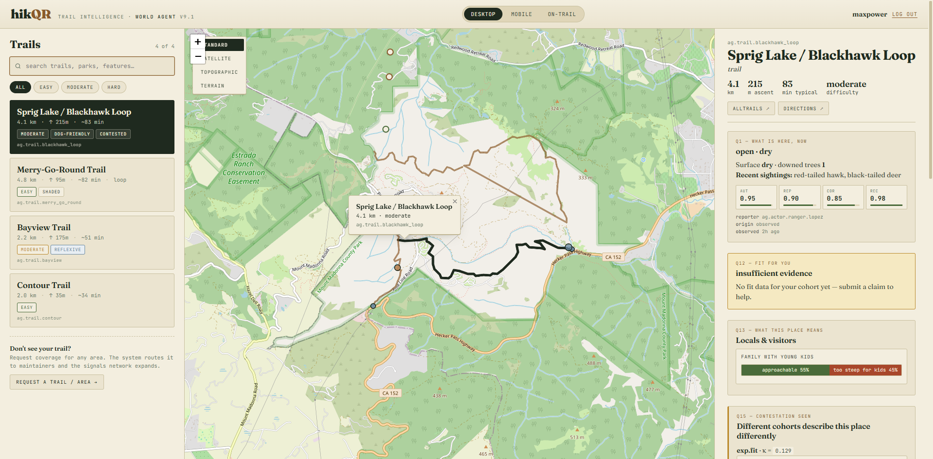
HikQR trail intelligence interface showing trail list, topographic map, and World Agent question panels for Sprig Lake Blackhawk Loop
What the interface shows
Q1: What Is Here, Now

Live trail conditions

Surface status, obstacles, recent wildlife sightings. Each observation carries authority, reporter identity, recency, and corroboration scores.

Trust-scored · attributed · temporal
Q12: Fit for You

Cohort-conditioned fitness

The same trail gets different assessments for different hikers. A family with young kids sees "approachable 55% / too steep for kids 45%." When evidence is insufficient, the system says so explicitly.

Personalized · evidence-gated
Q15: Contestation Seen

Disagreement surfaced, not hidden

Different cohorts describe the same trail differently. The system surfaces the disagreement with a contestation coefficient rather than averaging it away.

Transparent conflict · no false consensus

Three posture rules
that define the system

01

Index, don't collect

The world's information stays where it lives. World Agent indexes and references. It does not extract, hoard, or create shadow copies of reality.

02

Report belief, not truth

Every answer carries lineage, confidence, and contestation. The system tells you what it believes, how strongly, and who disagrees.

03

Local-first, consent-bound

Personal data stays on-device by default. Spatial intelligence flows upward only with explicit consent, never by assumption.

"The art of the elegant fail: a useful spatial intelligence layer is one that fails honestly."

Max Power

One API call to query
any place on Earth

The World Agent API gives your application structured spatial intelligence in a single request. Specify a place, the questions to ask, an execution mode, and optional cohort context, and receive grounded answers with full lineage. Full SDK documentation and API reference are available to design partners under NDA.

Request
place
canonical place reference
questions
which canonical questions to answer
mode
latency vs. lineage tradeoff
cohort
optional cohort context
Response
answers
structured per-question results
lineage
provenance chain for every answer
confidence
stated, not assumed
contestation
surfaced where cohorts disagree

Multiple execution modes span robotics-grade latency through decision-grade depth, with structured fallback between them and explicit failure classes when evidence is insufficient.

Join the design
partner program.

We're onboarding design partners building spatial copilots, robotics, and next-generation location-aware applications.

Or: Read the public specification · Request the v9 paper · Subscribe to research updates

Researchers, academic collaborators, and technical reviewers: we engage with serious technical interest even before commercial conversations.

Enter Code or Contact Us for Access

Request access →